Archive

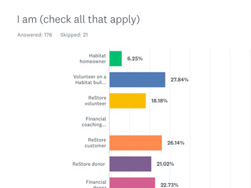
[caption id="attachment_1274" align="alignnone" width="300"] Survey for the Capital Ringers[/caption] To enhance community engagement, Lee Ann has developed and deployed online surveys using her premium Survey Monkey account. The analyzed results have informed projects from comprehensive and strategic plans to music nonprofits searches for clergy. In 2019-20, she...

[caption id="attachment_991" align="alignright" width="496"] Lee Ann working on the Capital Ringers' website she designed. [/caption] Lee Ann has built more than 25 WordPress websites for churches, community planning projects, nonprofits and other clients. She is a certified web and graphic designer, commuting from Sussex County to...

Using ArcGIS Online tools, Cedar Creek can create interactive web maps that graphically depict all kinds of demographic information.  Depending on the project, these maps can be embedded into a presentation or story map. Here are a few examples: Latino Concentrations in Delaware Prepared for the Episcopal...

Story maps can use a combination of interactive maps, photos, videos and links to provide spatial information in a visually appealing, reader-friendly way. Lee Ann has produced several story maps, including these two for Laurel. The first uses the new cascading template to produce full-frame...

[caption id="attachment_1104" align="alignright" width="300"] An advisory team helped develop guiding principles for the Town of Laurel's 10-year comprehensive plan.[/caption] Laurel's updated 10-year comprehensive plan was approved by the Mayor and Council in October 2017. Cedar Creek Planners prepared the draft and final plan over two years. Lee...